
Today, we hiked to the Cold War bunker, a wonderful best kept secret … all the people I talked to had no idea this existed.
I pulled this off the Internet …
An easy trail leads to an abandoned cold war bunker originally intended to house important documents should Canada be threatened.
From the parking lot of the Heart Creek day use area take the path leading west. It’s washed out a short way down the trail so make your way around it and carry on until you come to a marker post for the Trans Canada Trail. Take a left here and continue until you come to an intersection and another TCT marker, take the left path here as well. The trail gradually switchbacks from here to the entrance of the bunker. Bring a decent flash light if you plan on exploring.
Directions:
The Heart Creek day use area is on the south side of the Trans Canada Highway across from Lac des Arcs. It is accessible by both east and west bound traffic.
source: http://www.trailpeak.com/index.jsp?con=trail&val=3038
Here is a little more interesting information (http://highlineonline.ca/a-dark-secret-inside-the-bow-valleys-nuclear-bunker/) …
It is listed at 4km (which is return) and is pretty accurate .. my GPS had us at about 2.11km there and 2.15km return. The parking lot was completely full so we were a little worried that the bunker would be packed. Surprising, there wasn’t a lot of people hiking that way … most were going to Heart Mountain. It was a nice surprise as we really had a chance to get some pics and explore.
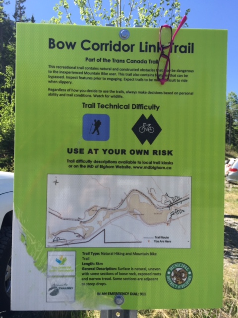
When you are looking for the trail head, look for the one that reads ‘Bow Corridor Link Trail’, it heads directly west from the parking lot, parallel the highway – here is a pic of the sign …
The bunker itself was pretty cool, I would recommend a jacket if it isn’t as hot out as the inside is quite a bit cooler (especially if you are a person that runs cold). We ran into some people that took pics of an animal inside, it almost looked like a chinchilla of sorts but with a long tail. I tried to find it when I was in there, but couldn’t. The sad thing is there was a some pop and beer cans thrown about, this just ticks me off as some people have no respect.
Here are some pics …
The Pup in the first Pic is Courage, my friend’s rescue dog … she is a pretty awesome dog! The ‘tall drink of water’ is my other friend and then there is me with Courage in the foreground. There are two pics on the inside, the first one is with a flash, the second is not with just a little lighting from the entrance … there are parts where I did take pics and they are completely black.
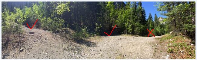
You do come to a fork in the road, there are three trails you can pick from. The one on the left is the one you want; the one in this middle is a loop and connects with the one on the left, so you can take that one as well. The one on the right is part of the TCT and heads off in a different direction …
I would totally recommend this hike!
